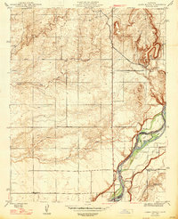
1947 Map of Lanes Bridge
USGS Topo · Published 1947About this map
The San Joaquin River defines the southeastern corner of this 1946 revision, serving as the boundary between Madera and Fresno counties. This landscape, as it appeared in the mid-1940s, is characterized by the emerging water infrastructure of the Central Valley, including the Madera Canal and the historic crossing at Lanes Bridge. The river's path is marked by fluvial features like Cobbs Island and Island No 1, which sit just north of the Fort Washington Golf Club.
Find a feature on this map
16 named features on this map. Tap any name to fly to it.
Don’t see what you’re looking for? This feature index may not catch every label — zoom into the map to look around manually.
Map Details
Editions of this 1947 Lanes Bridge Map
2 editions found
Other maps of this area

1912 · Mariposa
USGS Topo · 1:125,000

1916 · Sulphur Springs
USGS Topo · 1:24,000

1919 · Sulphur Springs
USGS Topo · 1:31,680

1919 · Little Table Mountain
USGS Topo · 1:31,680

1921 · Daulton
USGS Topo · 1:31,680

1921 · Bullard
USGS Topo · 1:31,680

1922 · Lanes Bridge
USGS Topo · 1:31,680

1922 · Friant
USGS Topo · 1:31,680

1922 · Gregg
USGS Topo · 1:31,680

1923 · Herndon
USGS Topo · 1:31,680