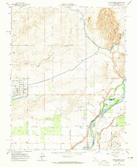
1964 Map of Lanes Bridge
USGS Topo · Published 1965About this map
San Joaquin River waters define the southern border of this landscape, separating Madera and Fresno counties during a period of expanding agricultural and residential development. The terrain transitions from the seasonal drainages of Little Dry Creek and Root Creek in the north to the managed irrigation of the Madera Canal. Pockets of local industry and recreation are evident at the Gravel Pit and the Fort Washington Country Club, while the presence of the Webster Sch and Fort Washington Sch highlights the established community centers. The map documents significant water management features, including a Gaging Station and several siphons and flumes along the canal system. Notable river landmarks such as Cobbs Ford and Island No 1 provide specific points of interest for those tracing historical navigation or crossing points in the vicinity of Lanes Bridge.
Find a feature on this map
37 named features on this map. Tap any name to fly to it.
Don’t see what you’re looking for? This feature index may not catch every label — zoom into the map to look around manually.
Map Details
Editions of this 1964 Lanes Bridge Map
3 editions found
Other maps of this area

1912 · Mariposa
USGS Topo · 1:125,000

1916 · Sulphur Springs
USGS Topo · 1:24,000

1919 · Sulphur Springs
USGS Topo · 1:31,680

1919 · Little Table Mountain
USGS Topo · 1:31,680

1921 · Daulton
USGS Topo · 1:31,680

1921 · Bullard
USGS Topo · 1:31,680

1922 · Lanes Bridge
USGS Topo · 1:31,680

1922 · Friant
USGS Topo · 1:31,680

1922 · Gregg
USGS Topo · 1:31,680

1923 · Herndon
USGS Topo · 1:31,680