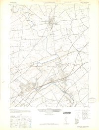
1944 Map of Langhorne
USGS Topo · Published 1947About this map
Neshaminy Creek meanders through this portion of Bucks County, shaping a landscape defined by evolving rail transportation and established educational institutions during the 1940s. The presence of the Reading Company and Pennsylvania Railroad lines, including stops at Holland Sta and Trevose Sta, highlights the area's role as a commuter and transit corridor between Philadelphia and its northern suburbs. Local landmarks such as the George School and the Villa Joseph Marie academy near the Sisters of St Casimir convent emphasize a rich history of private education and religious community. Smaller settlements like Langhorne Manor, Hulmeville, and Parkland are shown in detail, alongside aviation history at the Silver Star Airport. Notable water-powered industrial remnants are suggested by Mill Creek and Iron Works Creek, while a Covered Bridge still spans the Neshaminy in the northern reaches.
Find a feature on this map
56 named features on this map. Tap any name to fly to it.
Don’t see what you’re looking for? This feature index may not catch every label — zoom into the map to look around manually.
Map Details
Editions of this 1944 Langhorne Map
This is the sole edition of this map. No revisions or reprints were ever made.
Other maps of this area

1890 · Lambertville
USGS Topo · 1:62,500

1890 · Doylestown
USGS Topo · 1:62,500

1890 · Burlington
USGS Topo · 1:62,500

1891 · Lambertville
USGS Topo · 1:62,500

1891 · Doylestown
USGS Topo · 1:62,500

1893 · Germantown
USGS Topo · 1:62,500

1893 · Burlington
USGS Topo · 1:62,500

1894 · Lambertville
USGS Topo · 1:62,500

1894 · Germantown
USGS Topo · 1:62,500

1896 · Germantown
USGS Topo · 1:62,500
Featured Places
- Philadelphia, PA
- Bensalem Township, PA
- Middletown Township, PA
- Lower Makefield Township, PA
- Lower Southampton Township, PA