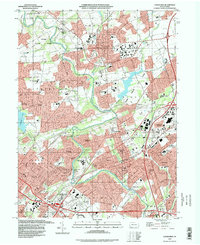
1993 Map of Langhorne
USGS Topo · Published 1998About this map
Neshaminy Creek meanders through this portion of Bucks County, anchoring a landscape defined by institutional campuses and burgeoning suburban developments in the early 1990s. The map highlights significant educational and medical centers, including the extensive grounds of the Eastern State Sch and Hosp and the Bucks County Community College near Newtown. The presence of established private institutions like the George Sch and Villa Joseph Marie High Sch alongside newer developments like Levittown illustrates the area's transition from a collection of historic boroughs to a densely populated corridor. Connectivity is dominated by the Pennsylvania Turnpike and U.S. Highway 1, which intersect near Neshaminy Falls. Public spaces such as Tyler State Park and Churchville County Park offer green breaks among the residential grids of Langhorne, Penndel, and Hulmeville.
Find a feature on this map
104 named features on this map. Tap any name to fly to it.
Don’t see what you’re looking for? This feature index may not catch every label — zoom into the map to look around manually.
Map Details
Editions of this 1993 Langhorne Map
This is the sole edition of this map. No revisions or reprints were ever made.
Other maps of this area

1890 · Lambertville
USGS Topo · 1:62,500

1890 · Doylestown
USGS Topo · 1:62,500

1890 · Burlington
USGS Topo · 1:62,500

1891 · Lambertville
USGS Topo · 1:62,500

1891 · Doylestown
USGS Topo · 1:62,500

1893 · Germantown
USGS Topo · 1:62,500

1893 · Burlington
USGS Topo · 1:62,500

1894 · Lambertville
USGS Topo · 1:62,500

1894 · Germantown
USGS Topo · 1:62,500

1896 · Germantown
USGS Topo · 1:62,500
Featured Places
- Philadelphia, PA
- Bensalem Township, PA
- Middletown Township, PA
- Lower Makefield Township, PA
- Lower Southampton Township, PA