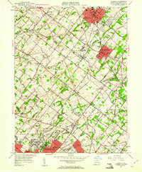
1951 Map of Lansdale
USGS Topo · Published 1961About this map
Norristown State Hospital For The Insane occupies a significant portion of the southern landscape, illustrating the scale of 1950s institutional campuses in Montgomery County. The area is defined by a dense network of suburban growth and rail infrastructure, with the Reading railroad connecting established centers like Lansdale, North Wales, and Norristown. Local aviation is well-represented by both the Lansdale Airport and Wings Field Airport, highlighting the mid-century transition toward expanded private flight. Numerous rural landmarks remain visible, from the Central Schwenkfelder Ch to the small Frog Hollow Sch. The path of the Pennsylvania Turnpike cuts diagonally through the townships, signifying the early era of high-speed transit that would soon transform these communities. Natural drainage via Wissahickon Creek and Towamencin Cr provides the topographic backbone for the surrounding settlements and country clubs.
Find a feature on this map
72 named features on this map. Tap any name to fly to it.
Don’t see what you’re looking for? This feature index may not catch every label — zoom into the map to look around manually.
Map Details
Editions of this 1951 Lansdale Map
2 editions found
Other maps of this area

1888 · Quakertown
USGS Topo · 1:62,500

1890 · Doylestown
USGS Topo · 1:62,500

1890 · Quakertown
USGS Topo · 1:62,500

1891 · Doylestown
USGS Topo · 1:62,500

1893 · Germantown
USGS Topo · 1:62,500

1894 · Quakertown
USGS Topo · 1:62,500

1894 · Norristown
USGS Topo · 1:62,500

1894 · Germantown
USGS Topo · 1:62,500

1895 · Norristown
USGS Topo · 1:62,500

1896 · Germantown
USGS Topo · 1:62,500