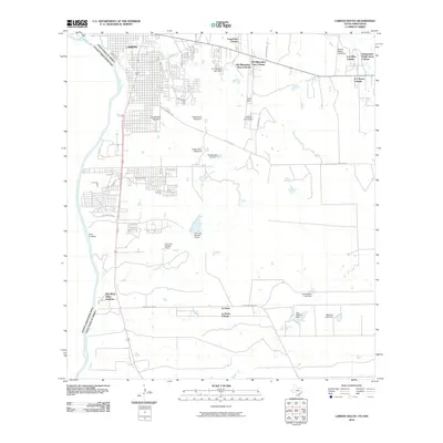
2010 Map of Laredo South
USGS Topo · Published 2010About this map
The Rio Grande serves as the international boundary on this map, separating Laredo from the Estados Unidos Mexicanos. The landscape south and east of the city is defined by a dense network of residential colonias, including LargaVista Colonia, One River Place Colonia, and La Presa Colonia. These settlements are interconnected by thoroughfares such as Mangana-Hein Rd and Wormser Rd, reflecting the modern expansion of Webb County.
Find a feature on this map
35 named features on this map. Tap any name to fly to it.
Don’t see what you’re looking for? This feature index may not catch every label — zoom into the map to look around manually.
Map Details
Editions of this 2010 Laredo South Map
This is the sole edition of this map. No revisions or reprints were ever made.
Other maps of this area

1933 · Becerra Creek
USGS Topo · 1:62,500

1956 · Islitas
USGS Topo · 1:62,500

1956 · Laredo East
USGS Topo · 1:62,500

1956 · Laredo
USGS Topo · 1:250,000

1965 · Laredo West
USGS Topo · 1:24,000

1965 · Tios Creek
USGS Topo · 1:24,000

1965 · Laredo East
USGS Topo · 1:24,000
1979 · Isla Mesteno
USGS Topo · 1:24,000

1979 · Laredo South
USGS Topo · 1:24,000

1979 · O'Keefe Lake
USGS Topo · 1:24,000
Featured Places
- Laredo, TX
- La Presa, TX
- Tanquecitos South Acres Colonia, TX
- Los Altos Colonia, Laredo
- Old Milwaukee West Colonia, TX