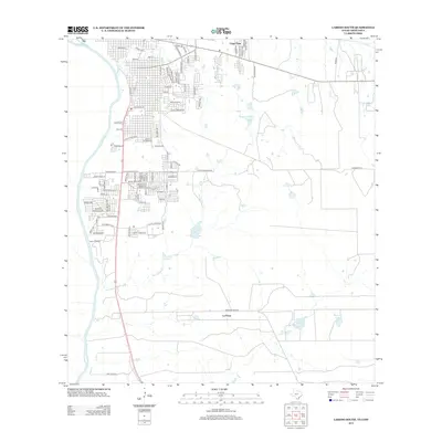
2013 Map of Laredo South
USGS Topo · Published 2013About this map
The Rio Grande flows along the western edge of this South Texas landscape, defining the international boundary south of Laredo. The terrain is marked by a complex network of ephemeral drainages such as Chacon Cr and San Idelfonso Cr, which feed into several man-made water features including the Rafael B Garcia Reservoir and the twin Link Lake Number 1 and Link Lake Number 2. Small-scale agricultural and ranching operations are evident at Dairy Crossing, while residential development clusters in settlements like Larga Vista and La Presa. The grid of the Laredo suburban fringe gives way to larger ranch tracts and specialized sites such as the San Ramon Fish Pond, illustrating the transition from urban density to the brush country of Webb County.
Find a feature on this map
94 named features on this map. Tap any name to fly to it.
Don’t see what you’re looking for? This feature index may not catch every label — zoom into the map to look around manually.
Map Details
Editions of this 2013 Laredo South Map
This is the sole edition of this map. No revisions or reprints were ever made.
Other maps of this area

1933 · Becerra Creek
USGS Topo · 1:62,500

1956 · Islitas
USGS Topo · 1:62,500

1956 · Laredo East
USGS Topo · 1:62,500

1956 · Laredo
USGS Topo · 1:250,000

1965 · Laredo West
USGS Topo · 1:24,000

1965 · Tios Creek
USGS Topo · 1:24,000

1965 · Laredo East
USGS Topo · 1:24,000
1979 · Isla Mesteno
USGS Topo · 1:24,000

1979 · Laredo South
USGS Topo · 1:24,000

1979 · O'Keefe Lake
USGS Topo · 1:24,000
Featured Places
- Laredo, TX
- La Presa, TX
- Tanquecitos South Acres Colonia, TX
- Los Altos Colonia, Laredo
- Old Milwaukee West Colonia, TX