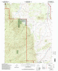
1994 Map of Larkspur
USGS Topo · Published 1998About this map
The Pike National Forest dominates the western landscape of this mid-1990s Colorado survey, where steep terrain gives way to the ranching and rail corridors of southern Douglas County. The dual rail lines of the At&Sf RR and D&Rgw RR parallel Plum Creek, marking the vital transport artery between Denver and Colorado Springs. Local ranching life is well-documented through named properties such as Green Valley Ranch and Crystal Springs Ranch, while the northern town of Larkspur and the southern edge of Palmer Lake anchor the region's residential growth.
Find a feature on this map
29 named features on this map. Tap any name to fly to it.
Don’t see what you’re looking for? This feature index may not catch every label — zoom into the map to look around manually.
Map Details
Editions of this 1994 Larkspur Map
This is the sole edition of this map. No revisions or reprints were ever made.
Other maps of this area

1893 · Platte Canyon
USGS Topo · 1:125,000

1894 · Castle Rock
USGS Topo · 1:125,000

1913 · Castle Rock
USGS Topo · 1:125,000

1940 · Castle Rock
USGS Topo · 1:62,500

1945 · Castle Rock
USGS Topo · 1:62,500

1953 · Denver
USGS Topo · 1:250,000

1954 · Devils Head
USGS Topo · 1:24,000
1954 · Monument
USGS Topo · 1:24,000
1954 · Greenland
USGS Topo · 1:24,000

1954 · Mount Deception
USGS Topo · 1:24,000