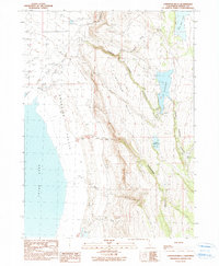
1990 Map of Larkspur Hills
USGS Topo · Published 1990About this map
Surprise Valley and the Larkspur Hills define this high-desert basin in Modoc County, where water management is the primary driver of the landscape. The western portion of the map is dominated by the expansive, ephemeral bed of Upper Lake, while the eastern terrain rises into complex drainages like Lieberman Canyon. Human interaction with this arid environment is most evident in the development of water resources, including the Fee Reservoir and localized points such as Conlan Spring. These features, along with the intermittent flows of First Creek and Second Creek, highlight the seasonal nature of the region's hydrology. The transition from the flat alkali lakebed to the steep, eroded slopes of Poison Springs Canyon illustrates the isolation and specialized land use common to northeastern California's remote ranching and grazing corridors.
Find a feature on this map
14 named features on this map. Tap any name to fly to it.
Don’t see what you’re looking for? This feature index may not catch every label — zoom into the map to look around manually.
Map Details
Editions of this 1990 Larkspur Hills Map
This is the sole edition of this map. No revisions or reprints were ever made.
Other maps of this area

1886 · Alturas
USGS Topo · 1:250,000

1889 · Long Valley
USGS Topo · 1:250,000

1892 · Alturas
USGS Topo · 1:250,000

1954 · Vya
USGS Topo · 1:250,000

1954 · Alturas
USGS Topo · 1:250,000

1958 · Alturas
USGS Topo · 1:250,000

1958 · Vya
USGS Topo · 1:250,000

1962 · Alturas
USGS Topo · 1:250,000

1962 · Vya
USGS Topo · 1:250,000

1962 · Cedarville
USGS Topo · 1:62,500