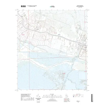
2020 Map of Larose
USGS Topo · Published 2020About this map
Bayou Lafourche serves as the primary artery for settlement in this coastal reach of Louisiana, anchoring a chain of communities including Valentine, Ludevine, and Larose. The landscape is defined by the transition from linear riverside development to the expansive wetlands and marsh systems that dominate the southern half of the quadrangle. Significant water management and transportation infrastructure is evident through the path of the Intracoastal Waterway and the Grand Bayou Canal, alongside numerous drainage features like the Forty Arpent Canal and Middle Bayou. Family and plantation history is deeply etched into the local geography, seen in road names such as Edna Plantation Rd, Bollinger Rd, and Authement Rd. These labels offer a detailed look at land division and lineage in a region where the bayou was the historic front door for every homestead.
Find a feature on this map
76 named features on this map. Tap any name to fly to it.
Don’t see what you’re looking for? This feature index may not catch every label — zoom into the map to look around manually.
Map Details
Editions of this 2020 Larose Map
This is the sole edition of this map. No revisions or reprints were ever made.
Other maps of this area

1892 · Cut-Off
USGS Topo · 1:62,500

1892 · Houma
USGS Topo · 1:62,500

1894 · Lake Felicity
USGS Topo · 1:62,500

1894 · Dulac
USGS Topo · 1:62,500

1932 · Houma SE
USGS Topo · 1:31,680

1932 · Houma NE
USGS Topo · 1:31,680

1935 · Viguerie Canal
USGS Topo · 1:31,680

1935 · Montegut
USGS Topo · 1:31,680

1935 · Golden Meadow
USGS Topo · 1:31,680

1939 · Cut-Off
USGS Topo · 1:62,500