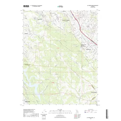
2018 Map of Las Trampas Ridge
USGS Topo · Published 2018About this map
Las Trampas Ridge dominates this 2018 survey of the East Bay, separating the suburban developments of Lafayette, Walnut Creek, and Alamo from the more secluded drainages of Bollinger Canyon Cr and Miller Canyon. The map reveals the sophisticated interface between urban growth and protected natural spaces, specifically featuring the Eugene O'Neill National Historic Site and the Iron Horse Regional Trail. These corridors preserve the region's cultural and transit history amidst modern expansion. From the residential streets of Danville to the high points of Las Trampas Peak and Ramage Peak, the map documents the complex topography and hydrology that shape the boundary between Contra Costa and Alameda counties. Waterways like San Ramon Cr and San Leandro Cr provide a framework for the valley floor, while the San Leandro Tunnel indicates the underlying infrastructure necessary to support the communities of Oakland and San Ramon.
Find a feature on this map
195 named features on this map. Tap any name to fly to it.
Don’t see what you’re looking for? This feature index may not catch every label — zoom into the map to look around manually.
Map Details
Editions of this 2018 Las Trampas Ridge Map
This is the sole edition of this map. No revisions or reprints were ever made.
Other maps of this area

1896 · Mt. Diablo
USGS Topo · 1:62,500

1897 · Concord
USGS Topo · 1:62,500

1898 · Mt. Diablo
USGS Topo · 1:62,500

1899 · Haywards
USGS Topo · 1:62,500

1906 · Pleasanton
USGS Topo · 1:62,500

1915 · Haywards
USGS Topo · 1:62,500

1915 · Concord
USGS Topo · 1:62,500

1941 · Pleasanton
USGS Topo · 1:62,500

1942 · Concord
USGS Topo · 1:62,500

1942 · Hayward
USGS Topo · 1:62,500