1962 Map of Las Vegas
USGS Topo · Published 1962About this map
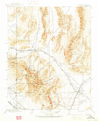
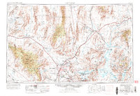
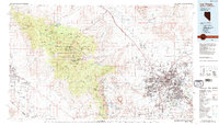
Las Vegas and North Las Vegas serve as the central hub of this Southern Nevada landscape, surrounded by a complex network of military and industrial developments in the early 1960s. The map illustrates the sprawl of Nellis AFB and the Las Vegas Bombing and Gunnery Range, emphasizing the region's importance to national defense during the Cold War. To the southeast, the industrial presence of a large Magnesium Plant near Henderson reflects the area's manufacturing roots. Beyond the urban centers, the Union Pacific railroad corridor links smaller settlements like Sloan and Arden. The eastern portion of the sheet is dominated by the waters of Lake Mead, formed by the Colorado River, and the Lake Mead National Recreation Area, while the Moapa Indian Reservation sits north of the Muddy River. To the west, the Spring Mountains and Toiyabe National Forest provide a sharp contrast to the arid Las Vegas Valley.
Find a feature on this map
55 named features on this map. Tap any name to fly to it.
Don’t see what you’re looking for? This feature index may not catch every label — zoom into the map to look around manually.
Map Details
Editions of this 1962 Las Vegas Map
This is the sole edition of this map. No revisions or reprints were ever made.
Historical Maps of Santa Fe Vistas Through Time
8 maps found