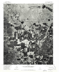
1973 Map of Las Vegas NW
USGS Topo · Published 1978About this map
Las Vegas and its northern expansion are captured here in a series of orthophotographic tiles from the early 1970s. This aerial perspective, prepared in cooperation with the U. S. Soil Conservation Service, reveals a landscape in the midst of rapid suburban development. Dense residential blocks and gridded streets push outward from the established hubs of North Las Vegas into the surrounding desert floor. The North Las Vegas Air Terminal stands as a prominent focal point in the northwest, its runways carved into the scrubland. This specific type of imagery allows for a rare, clear visualization of how the city’s residential footprint and transportation corridors were established before later decades of further expansion reshaped the valley's edge.
Find a feature on this map
3 named features on this map. Tap any name to fly to it.
Don’t see what you’re looking for? This feature index may not catch every label — zoom into the map to look around manually.
Map Details
Editions of this 1973 Las Vegas NW Map
This is the sole edition of this map. No revisions or reprints were ever made.
Other maps of this area

1907 · Las Vegas
USGS Topo · 1:250,000

1908 · Las Vegas
USGS Topo · 1:250,000

1952 · Corn Creek Springs
USGS Topo · 1:62,500

1952 · Gass Peak
USGS Topo · 1:62,500

1952 · Blue Diamond
USGS Topo · 1:62,500

1952 · Las Vegas
USGS Topo · 1:62,500

1954 · Las Vegas
USGS Topo · 1:250,000

1957 · Las Vegas
USGS Topo · 1:250,000

1959 · Las Vegas
USGS Topo · 1:250,000

1962 · Las Vegas
USGS Topo · 1:250,000