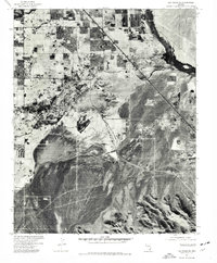
1973 Map of Las Vegas SE
USGS Topo · Published 1977About this map
Paradise and Henderson define the developing northern and eastern edges of this Mojave Desert landscape during the mid-1970s. The orthophotograph, derived from aerial photography taken in late 1973, reveals the rapid transition from open desert to organized suburban grids. This specific perspective highlights how development was creeping south toward the foothills of the Mc Cullough Range, which occupies the southern portion of the sheet. The iron lifeline of the Union Pacific railroad cuts a diagonal line across the valley, serving as a fixed industrial boundary for the expanding residential footprints. This orthophoto quadrangle is particularly useful for observing early land-clearing patterns and the initial infrastructure that preceded the massive growth of the late twentieth century.
Find a feature on this map
4 named features on this map. Tap any name to fly to it.
Don’t see what you’re looking for? This feature index may not catch every label — zoom into the map to look around manually.
Map Details
Editions of this 1973 Las Vegas SE Map
This is the sole edition of this map. No revisions or reprints were ever made.
Other maps of this area

1886 · Camp Mohave
USGS Topo · 1:250,000

1886 · Saint Thomas
USGS Topo · 1:250,000

1892 · Camp Mohave
USGS Topo · 1:250,000

1893 · Saint Thomas
USGS Topo · 1:250,000

1907 · Las Vegas
USGS Topo · 1:250,000

1908 · Las Vegas
USGS Topo · 1:250,000

1910 · Ivanpah
USGS Topo · 1:250,000

1912 · Ivanpah
USGS Topo · 1:250,000

1926 · Nelson
USGS Topo · 1:96,000

1926 · Boulder Canyon
USGS Topo · 1:96,000