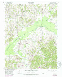
1956 Map of Latham
USGS Topo · Published 1985About this map
The North Fork Obion River carves through the rural landscape of Weakley County, defining the agricultural and settlement patterns of this Tennessee region. Centered on the community of Latham, the area is characterized by a dense network of small rural institutions that suggest a tightly knit community structure. The map reveals numerous country churches and schools such as Bible Union Sch and Welsh Sch, alongside landmarks like Hatler Chapel and Pisgah Ch. These points of assembly, often paired with local burial grounds like the Brundige Cem or Austin Springs Cem, mark the persistent social hubs of the mid-20th-century countryside.
Find a feature on this map
47 named features on this map. Tap any name to fly to it.
Don’t see what you’re looking for? This feature index may not catch every label — zoom into the map to look around manually.
Map Details
Editions of this 1956 Latham Map
2 editions found
Other maps of this area

1950 · Martin
USGS Topo · 1:24,000

1952 · Dresden
USGS Topo · 1:24,000

1952 · Cuba
USGS Topo · 1:24,000

1952 · Water Valley
USGS Topo · 1:24,000

1952 · Mayfield
USGS Topo · 1:62,500

1952 · Water Valley
USGS Topo · 1:62,500
1952 · Lynnville
USGS Topo · 1:24,000

1956 · Mc Connell
USGS Topo · 1:24,000

1956 · Latham
USGS Topo · 1:24,000
1956 · Palmersville
USGS Topo · 1:24,000