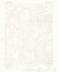
1967 Map of Laughlin Gulch
USGS Topo · Published 1969About this map
Rio Grande National Forest dominates this landscape in the late 1960s, a rugged high-altitude terrain defined by deep drainages and cattle-grazing infrastructure. The Laughlin Stock Driveway cuts across the northern slopes, providing a critical route for moving livestock through the mountains between Saguache Creek and the southern parklands. The topography is marked by significant peaks like Sierra de La Lola, Spruce Mountain, and Tracy Mountain, which tower over the intricate network of gulches including Housetop Gulch and Laughlin Gulch. Evidence of seasonal use and remote passage is found at Big Springs Campground and the San Juan Creek Trail, while Fullerton Park sits in the southern portion of the quadrangle. Springs such as Boland Spring and Houghland Hill Spring provide vital water sources in this dry mountain environment where water drainage is funneled through Mill Creek and Tracy Canyon.
Find a feature on this map
24 named features on this map. Tap any name to fly to it.
Don’t see what you’re looking for? This feature index may not catch every label — zoom into the map to look around manually.
Map Details
Editions of this 1967 Laughlin Gulch Map
2 editions found
Other maps of this area

1915 · Del Norte
USGS Topo · 1:125,000

1917 · Del Norte
USGS Topo · 1:125,000

1945 · Durango
USGS Topo · 1:250,000

1953 · Durango
USGS Topo · 1:250,000

1954 · Durango
USGS Topo · 1:250,000

1956 · Montrose
USGS Topo · 1:250,000

1959 · Montrose
USGS Topo · 1:250,000

1960 · Montrose
USGS Topo · 1:250,000

1961 · Durango
USGS Topo · 1:250,000

1963 · Durango
USGS Topo · 1:250,000