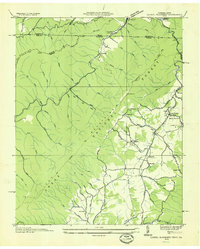
1935 Map of Laurel Bloomery
USGS Topo · Published 1935About this map
Laurel Bloomery and the surrounding high country of the Iron Mountains are documented here during a period of transition in the mid-1930s. The map illustrates the early development of recreational and conservation infrastructure, notably featuring the Appalachian Trail as it winds through the National Forest and the presence of Camp McArthur CCC. Settlement patterns follow the narrow valleys of Beaverdam Creek and Laurel Creek, where small communities like Eureka and Sutherland sit alongside numerous family-named water branches. Local social centers are well-represented, including the Pleasant Home Ch, Wesley Chapel, and rural schoolhouses such as Fairview Sch and Wills Sch. This survey, compiled from aerial photographs and field examinations by the Tennessee Valley Authority, captures the rugged borderlands between Tennessee and Virginia before modern highway expansions altered these mountain hollows.
Find a feature on this map
70 named features on this map. Tap any name to fly to it.
Don’t see what you’re looking for? This feature index may not catch every label — zoom into the map to look around manually.
Map Details
Editions of this 1935 Laurel Bloomery Map
This is the sole edition of this map. No revisions or reprints were ever made.
Other maps of this area

1891 · Abingdon
USGS Topo · 1:125,000

1893 · Cranberry
USGS Topo · 1:125,000

1894 · Abingdon
USGS Topo · 1:125,000

1895 · Cranberry
USGS Topo · 1:125,000

1899 · Cranberry
USGS Topo · 1:125,000

1902 · Cranberry
USGS Topo · 1:125,000

1909 · Abingdon
USGS Topo · 1:96,000

1911 · Abingdon
USGS Topo · 1:125,000

1935 · Konnarock
USGS Topo · 1:24,000
1935 · Abingdon
USGS Topo · 1:24,000