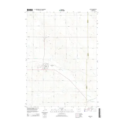
2014 Map of Laurel
USGS Topo · Published 2014About this map
Laurel serves as the primary hub in this corner of Northeast Nebraska, situated where several branches of the Logan Creek watershed converge. The town's grid is anchored by streets like Alma St and Elm St, with the Laurel Municipal Airport and Laurel Cem defining its outskirts. The map illustrates a landscape heavily modified by drainage engineering, notably the Logan Cr Dredge which cuts a straight path across the terrain south of town. This feature, along with the Old Channel Logan Creek, reveals how the natural hydrology of Middle Logan Cr and Baker Cr was altered to support the surrounding agricultural grid. The boundary between Cedar Co and Dixon Co runs along the eastern edge of the quadrangle, following the section lines that define the local road network.
Find a feature on this map
42 named features on this map. Tap any name to fly to it.
Don’t see what you’re looking for? This feature index may not catch every label — zoom into the map to look around manually.
Map Details
Editions of this 2014 Laurel Map
This is the sole edition of this map. No revisions or reprints were ever made.
Other maps of this area

1898 · Elk Point
USGS Topo · 1:125,000

1901 · Elk Point
USGS Topo · 1:125,000

1907 · Elk Point
USGS Topo · 1:125,000

1955 · Sioux City
USGS Topo · 1:250,000

1958 · Sioux City
USGS Topo · 1:250,000

1959 · Sioux City
USGS Topo · 1:250,000

1964 · Martinsburg SW
USGS Topo · 1:24,000

1967 · Wakefield SW
USGS Topo · 1:24,000
1967 · Concord
USGS Topo · 1:24,000

1968 · Coleridge
USGS Topo · 1:24,000