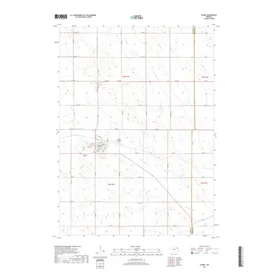
2017 Map of Laurel
USGS Topo · Published 2017About this map
Laurel serves as the focal point of this northeastern Nebraska landscape, positioned at the intersection of Cedar and Dixon counties. The town's grid is clearly defined, featuring residential streets like W 2nd St and W 4th St, with the Laurel Municipal Airport and Laurel Cem established on its outskirts. This 2017 survey reveals an environment shaped by water management, where the straight path of the Logan Cr Dredge contrasts sharply with the original meandering path of the Old Channel Logan Creek. The surrounding agricultural plains are drained by a network of waterways including Middle Logan Cr, N Logan Cr, and Baker Cr. The rural road network, comprised of routes such as 874th Rd and 870th Rd, follows the classic township and range system, providing a high level of detail for those tracing specific family landholdings or rural property lines in this corner of the state.
Find a feature on this map
34 named features on this map. Tap any name to fly to it.
Don’t see what you’re looking for? This feature index may not catch every label — zoom into the map to look around manually.
Map Details
Editions of this 2017 Laurel Map
This is the sole edition of this map. No revisions or reprints were ever made.
Other maps of this area

1898 · Elk Point
USGS Topo · 1:125,000

1901 · Elk Point
USGS Topo · 1:125,000

1907 · Elk Point
USGS Topo · 1:125,000

1955 · Sioux City
USGS Topo · 1:250,000

1958 · Sioux City
USGS Topo · 1:250,000

1959 · Sioux City
USGS Topo · 1:250,000

1964 · Martinsburg SW
USGS Topo · 1:24,000

1967 · Wakefield SW
USGS Topo · 1:24,000
1967 · Concord
USGS Topo · 1:24,000

1968 · Coleridge
USGS Topo · 1:24,000