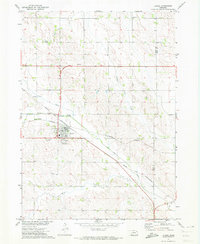
1971 Map of Laurel
USGS Topo · Published 1973About this map
Laurel serves as the primary hub in this early 1970s survey of northeastern Nebraska, situated at the busy intersection of the Chicago and North Western and Burlington Northern railroads. This dual-rail infrastructure highlights the town's role as a regional transport point for agricultural interests. The surrounding landscape in Cedar Co and Dixon Co is defined by a network of waterways including Middle Logan Creek and Perrin Creek, which carve through the terrain. Civic and social life is anchored by landmarks such as Laurel Cem and the Cedar View Country Club on the town's southern edge. Rural community centers appear further afield, notably at the Logan Center Ch and the Golden Prairie Sch, illustrating the dispersed settlement pattern characteristic of the Missouri River Basin development era.
Find a feature on this map
18 named features on this map. Tap any name to fly to it.
Don’t see what you’re looking for? This feature index may not catch every label — zoom into the map to look around manually.
Map Details
Editions of this 1971 Laurel Map
This is the sole edition of this map. No revisions or reprints were ever made.
Other maps of this area

1898 · Elk Point
USGS Topo · 1:125,000

1901 · Elk Point
USGS Topo · 1:125,000

1907 · Elk Point
USGS Topo · 1:125,000

1955 · Sioux City
USGS Topo · 1:250,000

1958 · Sioux City
USGS Topo · 1:250,000

1959 · Sioux City
USGS Topo · 1:250,000

1964 · Martinsburg SW
USGS Topo · 1:24,000

1967 · Wakefield SW
USGS Topo · 1:24,000
1967 · Concord
USGS Topo · 1:24,000

1968 · Coleridge
USGS Topo · 1:24,000