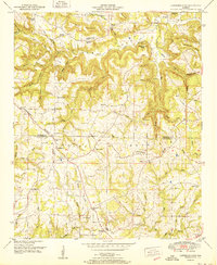
1951 Map of Lawrence Cove
USGS Topo · Published 1951About this map
Lawrence Cove sits at the base of Self Mountain in this 1951 study of the boundary between Morgan and Cullman Counties. The landscape is defined by the Tennessee Valley Divide, where numerous branches and creeks like Cotaco Creek and Duck Creek carve out a series of steep hollows including Martin Hollow and Bates Hollow. The map reveals a high density of rural social centers, particularly churches such as Friendship Ch, Macedonia Ch, and Mt Pisgah Ch, often paired with small family or community burial grounds like Canaan Cem. Evidence of early education appears at the Lawrence Cove School and Springer Ch School, marking these small agricultural hubs. The presence of Ruins near the Fork of the creek suggests older habitations and historical land use along the established roads connecting Pruitt and Fairview.
Find a feature on this map
67 named features on this map. Tap any name to fly to it.
Don’t see what you’re looking for? This feature index may not catch every label — zoom into the map to look around manually.
Map Details
Editions of this 1951 Lawrence Cove Map
2 editions found
Other maps of this area

1888 · Cullman
USGS Topo · 1:125,000

1892 · Cullman
USGS Topo · 1:125,000

1936 · Hulaco
USGS Topo · 1:24,000

1936 · Eva
USGS Topo · 1:24,000

1936 · Somerville
USGS Topo · 1:24,000

1936 · Lawrence Cove
USGS Topo · 1:24,000

1936 · Center Grove
USGS Topo · 1:24,000

1936 · Holly Pond
USGS Topo · 1:24,000
1936 · Newsome Sinks
USGS Topo · 1:24,000
1947 · Newsome Sinks
USGS Topo · 1:24,000