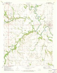
1971 Map of Le Roy
USGS Topo · Published 1973About this map
The Neosho River meanders through this portion of eastern Kansas, carving the broad Neosho Valley across the landscape of Neosho and Liberty townships. The town of Le Roy sits on the river's eastern bend, serving as a focal point for the surrounding agricultural and industrial activity. Evidence of the region's transport history is visible in the Old Railroad Grade and the active Missouri Pacific line, which intersect near the town center.
Find a feature on this map
20 named features on this map. Tap any name to fly to it.
Don’t see what you’re looking for? This feature index may not catch every label — zoom into the map to look around manually.
Map Details
Editions of this 1971 Le Roy Map
This is the sole edition of this map. No revisions or reprints were ever made.
Other maps of this area

1885 · Burlington
USGS Topo · 1:125,000

1886 · Fredonia
USGS Topo · 1:125,000

1894 · Fredonia
USGS Topo · 1:125,000

1894 · Burlington
USGS Topo · 1:125,000

1947 · Lawrence
USGS Topo · 1:250,000

1947 · Joplin
USGS Topo · 1:250,000

1949 · Joplin
USGS Topo · 1:250,000

1950 · Lawrence
USGS Topo · 1:250,000

1954 · Joplin
USGS Topo · 1:250,000

1956 · Lawrence
USGS Topo · 1:250,000