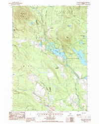
1987 Map of Lead Mountain
USGS Topo · Published 1988About this map
The Narraguagus River carves through this late 20th-century landscape, anchoring a network of glacial lakes and rugged ridgelines along the border of Hancock and Washington counties. Settled clusters at Beddington and Lower Beddington sit near the shores of Beddington Lake, where a Boat Ramp suggests the importance of water access for local recreation and industry. The topography is defined by prominent elevations such as Lead Mountain and Spruce Mtn, with smaller water bodies like Chalk Pond and Mountain Pond tucked between the peaks. Local infrastructure is sparse but specific, including a Cem and multiple Gravel Pit operations, reflecting the area's transition between managed timberlands and seasonal residences. Large township divisions like T 22 M D and Deblois underscore the organized yet rural nature of this Down East interior.
Find a feature on this map
38 named features on this map. Tap any name to fly to it.
Don’t see what you’re looking for? This feature index may not catch every label — zoom into the map to look around manually.
Map Details
Editions of this 1987 Lead Mountain Map
This is the sole edition of this map. No revisions or reprints were ever made.
Other maps of this area

1902 · Cherryfield
USGS Topo · 1:62,500

1904 · Cherryfield
USGS Topo · 1:62,500

1929 · Lead Mountain
USGS Topo · 1:48,000

1930 · Tunk Lake
USGS Topo · 1:48,000

1932 · Tunk Lake
USGS Topo · 1:62,500

1932 · Lead Mountain
USGS Topo · 1:62,500

1941 · Tug Mountain
USGS Topo · 1:62,500

1942 · Cherryfield
USGS Topo · 1:62,500

1942 · Tunk Lake
USGS Topo · 1:62,500

1943 · Tug Mountain
USGS Topo · 1:62,500