1942 Map of Leadville
USGS Topo · Published 1943About this map
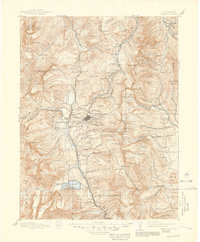
The Camp Hale Military Reservation dominates the northern landscape of this 1942 survey, reflecting the area's vital role in high-altitude training during the war. Located in the heart of the Rocky Mountains, the map centers on the high-elevation city of Leadville, surrounded by the industrial legacy of the Oro mining district and settlements like Stringtown and Bucktown. The transportation network is defined by the Denver and Rio Grande Western RR and the Colorado and Southern Ry, which hauled ore and supplies through steep passes. To the west, the U. S. Fish Hatchery sits near Turquoise Lake, while the southern reaches show the Twin Lakes Reservoir and the Arkansas River headwaters. Notable engineering works like the Carlton Tunnel and the Hagerman Tunnel appear as scars of the region's relentless mining and rail history.
Find a feature on this map
153 named features on this map. Tap any name to fly to it.
Don’t see what you’re looking for? This feature index may not catch every label — zoom into the map to look around manually.
Map Details
Editions of this 1942 Leadville Map
This is the sole edition of this map. No revisions or reprints were ever made.
Historical Maps of Breckenridge Through Time
9 maps found