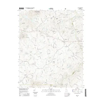
2014 Map of Leaf
USGS Topo · Published 2014About this map
Cleveland serves as the primary hub in this Georgia landscape where the foothills of the Chattahoochee National Forest meet the fertile valleys of White Creek and Mossy Creek. The area is characterized by a dense network of country churches and family burial grounds, such as Macedonia Cemetery and the Union Grove Cemetery, reflecting a deeply rooted rural community. Agricultural and industrial heritage is evident at Stovall Mill, while the southern reaches of the map show the influence of the Chattahoochee River as it passes through Buck Shoals and under the Sidney Lanier Bridge. The terrain transitions from prominent peaks like Skitt Mountain and Leadpole Mountain to the rolling lands surrounding settlements like Leaf, Pink, and Centerside, providing a clear view of the region's mid-2010s infrastructure and land use patterns before further modern expansion.
Find a feature on this map
77 named features on this map. Tap any name to fly to it.
Don’t see what you’re looking for? This feature index may not catch every label — zoom into the map to look around manually.
Map Details
Editions of this 2014 Leaf Map
This is the sole edition of this map. No revisions or reprints were ever made.
Other maps of this area

1886 · Dahlonega
USGS Topo · 1:125,000

1891 · Gainesville
USGS Topo · 1:125,000

1892 · Dahlonega
USGS Topo · 1:125,000

1896 · Dahlonega
USGS Topo · 1:125,000

1903 · Dahlonega
USGS Topo · 1:125,000

1935 · Cowrock
USGS Topo · 1:24,000

1938 · Cowrock
USGS Topo · 1:24,000
1950 · Cowrock
USGS Topo · 1:24,000

1951 · Cleveland
USGS Topo · 1:24,000
1952 · Cowrock
USGS Topo · 1:24,000