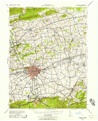
1943 Map of Lebanon
USGS Topo · Published 1958About this map
Reading Railroad railroad lines anchor the valley's industrial and agricultural transport as it appeared in the early 1940s, connecting the urban core of Lebanon with outlying boroughs and rural meeting houses. The landscape is defined by the transition from the Mountain ridge of State Game Lands No 80 in the north to the fertile creek valleys of the Little Swatara and Tulpehocken Creek. Local social history is deeply etched into the map through an extensive network of family-named schools and religious sites, such as Koehenderfers Sch and the Ginrich Meeting House. The area around Coleman Memorial Park reflects the established community structure of West Lebanon and Hebron, while smaller hamlets like Shirksville and Wintersville populate the rural intersections of the Lebanon and Berks county line.
Find a feature on this map
132 named features on this map. Tap any name to fly to it.
Don’t see what you’re looking for? This feature index may not catch every label — zoom into the map to look around manually.
Map Details
Editions of this 1943 Lebanon Map
2 editions found

Other maps of this area

1889 · Pottsville
USGS Topo · 1:62,500

1891 · Pottsville
USGS Topo · 1:62,500

1891 · Lebanon
USGS Topo · 1:62,500

1892 · Lykens
USGS Topo · 1:62,500

1892 · Hummelstown
USGS Topo · 1:62,500

1892 · Pine Grove
USGS Topo · 1:62,500

1893 · Lykens
USGS Topo · 1:62,500

1893 · Lebanon
USGS Topo · 1:62,500

1899 · Lebanon
USGS Topo · 1:62,500

1902 · Wernersville
USGS Topo · 1:62,500