1977 Map of Lebanon
USGS Topo · Published 1979About this map
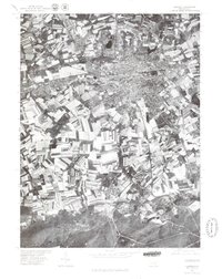
Lebanon serves as the dense urban anchor of this 1977 orthophotograph, where the tight grid of the city gives way to an intricate patchwork of agricultural fields and woodlands in Lebanon County. This aerial perspective, prepared in cooperation with the Soil Conservation Service, reveals the stark contrast between the industrial and residential corridors of Cleona and the more dispersed rural surroundings. To the south, the terrain shifts significantly as the open farmland meets the rising, forested slopes of the Furnace Hills. Smaller settlements like Quentin, Cornwall, and Rexmont are clearly visible, tucked into the valleys and along the edges of the upland terrain. This document provides a unique visual record of mid-century Pennsylvania land use, capturing the specific footprint of the region's towns and the surrounding landscape during the late 1970s.
Find a feature on this map
6 named features on this map. Tap any name to fly to it.
Don’t see what you’re looking for? This feature index may not catch every label — zoom into the map to look around manually.
Map Details
Editions of this 1977 Lebanon Map
This is the sole edition of this map. No revisions or reprints were ever made.
Other maps of this area

1891 · Lebanon
USGS Topo · 1:62,500

1892 · Hummelstown
USGS Topo · 1:62,500

1893 · Lebanon
USGS Topo · 1:62,500

1899 · Lebanon
USGS Topo · 1:62,500

1902 · Lancaster
USGS Topo · 1:62,500

1904 · Lancaster
USGS Topo · 1:62,500

1908 · Middletown
USGS Topo · 1:62,500

1924 · Hummelstown
USGS Topo · 1:62,500

1943 · Lancaster
USGS Topo · 1:62,500

1943 · Lebanon
USGS Topo · 1:62,500