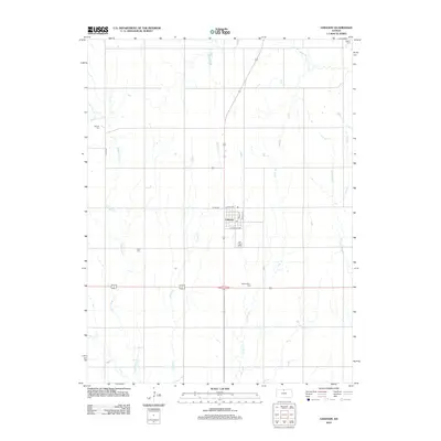
2012 Map of Lebanon
USGS Topo · Published 2012About this map
Lebanon serves as the central hub of this Smith County landscape, organized by a precise grid of local roads including S Railroad Ave and School Ave. The town's small-town infrastructure is centered around the Po and a network of agricultural lands drained by numerous small waterways. A distinct pattern of family and community heritage is evident through the distribution of several rural burial grounds across the township. To the northwest lies Oak Hill Cem, while Price Cem and Sweet Home Cem are situated along the drainage of Middle Oak Cr and E Oak Cr. The map further documents the headwaters and meandering paths of White Rock Cr, Spring Cr, and Frog Cr, illustrating the typical drainage patterns of the north-central Kansas plains.
Find a feature on this map
19 named features on this map. Tap any name to fly to it.
Don’t see what you’re looking for? This feature index may not catch every label — zoom into the map to look around manually.
Map Details
Editions of this 2012 Lebanon Map
This is the sole edition of this map. No revisions or reprints were ever made.
Other maps of this area

1893 · Smith Center
USGS Topo · 1:125,000

1894 · Mankato
USGS Topo · 1:125,000

1955 · Beloit
USGS Topo · 1:250,000

1959 · Beloit
USGS Topo · 1:250,000
1968 · Burr Oak NW
USGS Topo · 1:24,000
1969 · Cawker City NW
USGS Topo · 1:24,000
1969 · Esbon
USGS Topo · 1:24,000
1973 · Portis NE
USGS Topo · 1:24,000
1973 · Cora
USGS Topo · 1:24,000
1973 · Mc Cracken Branch
USGS Topo · 1:24,000