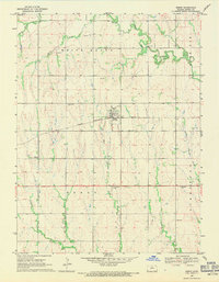
1969 Map of Esbon
USGS Topo · Published 1971About this map
The town of Esbon serves as the central hub of this Jewell County landscape, situated along the Chicago Rock Island and Pacific railroad. This 1960s-era survey reveals a rural society organized around its watercourses and small community landmarks, with White Rock Creek and Smith Creek winding through the northern sections. The presence of multiple cemeteries, including Salem Cem, Prairie Home Cem, and St Elizabeth Cem, provides essential data for genealogists tracing family roots in this part of Kansas. North of the rail line, the terrain is marked by White Mound, a distinctive geological feature. The map also documents the Westside Community Center and several small quarries, illustrating the local infrastructure and land use during a period when the rail network still played a vital role in the movement of grain and goods across the plains.
Find a feature on this map
18 named features on this map. Tap any name to fly to it.
Don’t see what you’re looking for? This feature index may not catch every label — zoom into the map to look around manually.
Map Details
Editions of this 1969 Esbon Map
2 editions found
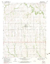
Other maps of this area

1893 · Smith Center
USGS Topo · 1:125,000

1894 · Mankato
USGS Topo · 1:125,000

1955 · Beloit
USGS Topo · 1:250,000

1959 · Beloit
USGS Topo · 1:250,000
1968 · Burr Oak NW
USGS Topo · 1:24,000

1968 · Burr Oak
USGS Topo · 1:24,000
1969 · Ionia
USGS Topo · 1:24,000
1969 · Cawker City NW
USGS Topo · 1:24,000
1969 · North Branch
USGS Topo · 1:24,000
1973 · Portis NE
USGS Topo · 1:24,000