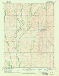
1969 Map of Ionia
USGS Topo · Published 1971About this map
Ionia serves as the central hub of this north-central Kansas landscape, situated where the Limestone Creek and Middle Limestone Creek drainage systems converge. The map illustrates a strictly organized agricultural grid, typical of the late 1960s, defined by section lines and township boundaries including Ionia, Limestone, and Calvin. A notable point of interest is the Jewell County State Park, which centers around a small reservoir on Ash Creek, providing a stark contrast to the surrounding upland grain fields. Genealogists will find the exact locations of the Ionia Cem and McGehee Cem useful for family research. The terrain is marked by several small quarries, suggesting localized stone extraction to support the area's rural road network, while the broader drainage is managed by watercourses like Browns Creek and Elm Creek.
Find a feature on this map
16 named features on this map. Tap any name to fly to it.
Don’t see what you’re looking for? This feature index may not catch every label — zoom into the map to look around manually.
Map Details
Editions of this 1969 Ionia Map
This is the sole edition of this map. No revisions or reprints were ever made.
Other maps of this area

1894 · Mankato
USGS Topo · 1:125,000

1955 · Beloit
USGS Topo · 1:250,000

1959 · Beloit
USGS Topo · 1:250,000

1962 · Cawker City
USGS Topo · 1:24,000

1962 · Glen Elder North
USGS Topo · 1:24,000

1962 · Jewell SW
USGS Topo · 1:24,000

1968 · Burr Oak
USGS Topo · 1:24,000
1969 · Cawker City NW
USGS Topo · 1:24,000

1969 · Mankato
USGS Topo · 1:24,000
1969 · Esbon
USGS Topo · 1:24,000