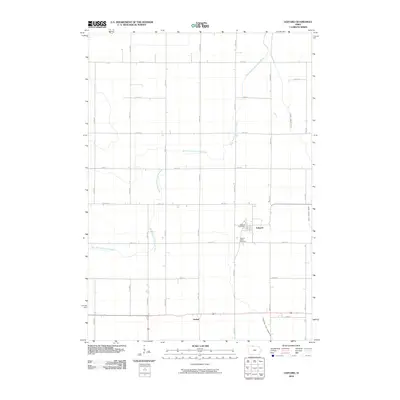
2010 Map of Ledyard
USGS Topo · Published 2010About this map
Ledyard and the smaller settlement of Gerled serve as the primary hubs in this northern Kossuth County landscape, defined by an extensive agricultural grid and a complex drainage system. The West Branch Blue Earth River meanders across the territory, its natural curves contrasting with the engineered precision of the Union Slough Ditch and Drainage Ditch Number 80. This network illustrates the intensive land management required for large-scale farming in the region. Local landmarks such as the Sacred Heart Cemetery and the Ledyard Post Office provide essential reference points for genealogists and local historians tracking family roots in this rural community. The map preserves the exact alignment of gravel roads like 150th Ave and 450th St as they appeared in the early 21st century.
Find a feature on this map
24 named features on this map. Tap any name to fly to it.
Don’t see what you’re looking for? This feature index may not catch every label — zoom into the map to look around manually.
Map Details
Editions of this 2010 Ledyard Map
This is the sole edition of this map. No revisions or reprints were ever made.
Other maps of this area

1954 · Fairmont
USGS Topo · 1:250,000

1958 · Fairmont
USGS Topo · 1:250,000

1967 · Pilot Grove
USGS Topo · 1:24,000

1967 · East Chain
USGS Topo · 1:24,000

1967 · Elmore
USGS Topo · 1:24,000

1972 · German Valley
USGS Topo · 1:24,000

1972 · Bancroft
USGS Topo · 1:24,000

1972 · Ledyard
USGS Topo · 1:24,000
1972 · Lakota
USGS Topo · 1:24,000

1980 · Swea City
USGS Topo · 1:24,000