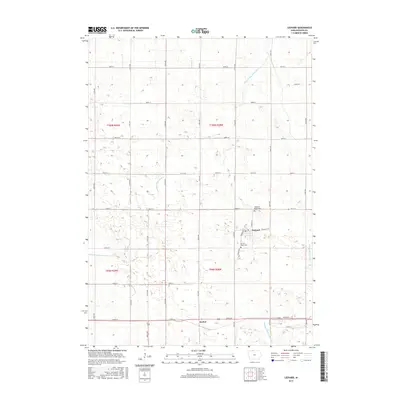
2015 Map of Ledyard
USGS Topo · Published 2015About this map
The town of Ledyard anchors this northern Iowa landscape, a community defined by its rigid section-line roads and its relationship with the drainage of the upper Midwest. To the south lies the small settlement of Gerled, situated along Highway 9. The terrain is marked by the winding courses of the West Br Blue Earth River and the W Br Blue Earth River, which cut across the geometric grid of 110th through 170th Avenues. For those researching local history, the map identifies key community sites such as Highland Home Cem and Sacred Heart Cem. The presence of the Union Slough Ditch and Drainage Ditch Number 80 illustrates the extensive engineering required to manage the wetlands and prairies of Kossuth County for agricultural productivity, a process that transformed the natural hydrology into the managed system seen here in the mid-2010s.
Find a feature on this map
35 named features on this map. Tap any name to fly to it.
Don’t see what you’re looking for? This feature index may not catch every label — zoom into the map to look around manually.
Map Details
Editions of this 2015 Ledyard Map
This is the sole edition of this map. No revisions or reprints were ever made.
Other maps of this area

1954 · Fairmont
USGS Topo · 1:250,000

1958 · Fairmont
USGS Topo · 1:250,000

1967 · Pilot Grove
USGS Topo · 1:24,000

1967 · East Chain
USGS Topo · 1:24,000

1967 · Elmore
USGS Topo · 1:24,000

1972 · German Valley
USGS Topo · 1:24,000

1972 · Bancroft
USGS Topo · 1:24,000

1972 · Ledyard
USGS Topo · 1:24,000
1972 · Lakota
USGS Topo · 1:24,000

1980 · Swea City
USGS Topo · 1:24,000