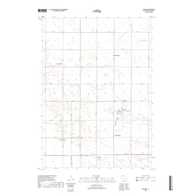
2018 Map of Ledyard
USGS Topo · Published 2018About this map
Ledyard serves as the primary hub of this northern Iowa agricultural landscape, situated at the intersection of Ledyard Rd and Edmunds St. The community's infrastructure includes a local Po and two distinct burial grounds nearby: Highland Home Cem to the north and Sacred Heart Cem on the town's western edge. The surrounding terrain is defined by a sophisticated water management network essential for prairie farming, featuring the meandering W Br Blue Earth River and engineered waterways like Union Slough Ditch and Drainage Ditch Number 80. To the south, the smaller settlement of Gerled sits along the southern highway corridor. The map preserves the strict section-line grid of rural Kossuth County, with numbered avenues and streets creating a precise framework for the expansive farmsteads that characterize this portion of the Tallgrass Prairie region.
Find a feature on this map
36 named features on this map. Tap any name to fly to it.
Don’t see what you’re looking for? This feature index may not catch every label — zoom into the map to look around manually.
Map Details
Editions of this 2018 Ledyard Map
This is the sole edition of this map. No revisions or reprints were ever made.
Other maps of this area

1954 · Fairmont
USGS Topo · 1:250,000

1958 · Fairmont
USGS Topo · 1:250,000

1967 · Pilot Grove
USGS Topo · 1:24,000

1967 · East Chain
USGS Topo · 1:24,000

1967 · Elmore
USGS Topo · 1:24,000

1972 · German Valley
USGS Topo · 1:24,000

1972 · Bancroft
USGS Topo · 1:24,000

1972 · Ledyard
USGS Topo · 1:24,000
1972 · Lakota
USGS Topo · 1:24,000

1980 · Swea City
USGS Topo · 1:24,000