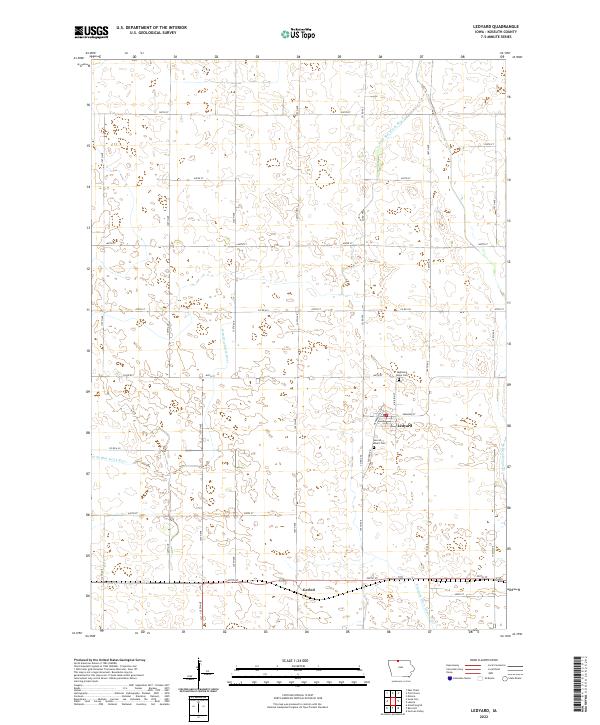
2022 Map of Ledyard
USGS Topo · Published 2022About this map
The town of Ledyard serves as the primary hub in this northern Iowa landscape, where the grid of sections and gravel roads meets the meandering course of the W Br Blue Earth River. In this agricultural region, the water management system is highly developed, featuring the Union Slough Ditch and the precisely engineered Drainage Ditch Number 80. To the south, the small settlement of Gerled sits along US Hwy 169, marking a secondary point of activity. Local history and genealogy are anchored at Highland Home Cem and Sacred Heart Cem, located just south of Ledyard's main streets like Edmunds St and Henderson St. This survey reflects a landscape defined by the intersection of natural river bends and the rigid township and range boundaries of t100n r29w and t99n r28w.
Find a feature on this map
38 named features on this map. Tap any name to fly to it.
Don’t see what you’re looking for? This feature index may not catch every label — zoom into the map to look around manually.
Map Details
Editions of this 2022 Ledyard Map
This is the sole edition of this map. No revisions or reprints were ever made.
Other maps of this area

1954 · Fairmont
USGS Topo · 1:250,000

1958 · Fairmont
USGS Topo · 1:250,000

1967 · Pilot Grove
USGS Topo · 1:24,000

1967 · East Chain
USGS Topo · 1:24,000

1967 · Elmore
USGS Topo · 1:24,000

1972 · German Valley
USGS Topo · 1:24,000

1972 · Bancroft
USGS Topo · 1:24,000

1972 · Ledyard
USGS Topo · 1:24,000
1972 · Lakota
USGS Topo · 1:24,000

1980 · Swea City
USGS Topo · 1:24,000