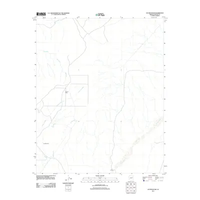
2011 Map of Lee Mountain
USGS Topo · Published 2011About this map
Lee Mountain and the broad expanse of Marcou Mesa anchor this Navajo County landscape, defined by an intricate network of desert drainage systems in the early 21st century. The map illustrates a dryland environment where water management is central to the land's utility, marked by scattered water features such as Badland Tank, Baldwin Tank, and the Lee Mountain Tanks. These human-made catchments, alongside the V K Windmill, support activity across a terrain carved by substantial seasonal channels including Joseph City Wash, Billy Wash, and Tanner Wash. In the southeastern corner, the wide bed of Leroux Wash cuts across the plains, showing the natural erosion patterns typical of this high desert region. The absence of dense settlements highlights the area's primary use for ranching or resource management, providing a clear record of land use and topographical detail in this part of northeastern Arizona.
Find a feature on this map
10 named features on this map. Tap any name to fly to it.
Don’t see what you’re looking for? This feature index may not catch every label — zoom into the map to look around manually.
Map Details
Editions of this 2011 Lee Mountain Map
This is the sole edition of this map. No revisions or reprints were ever made.
Other maps of this area

1883 · Tusayan
USGS Topo · 1:250,000

1886 · Tusayan
USGS Topo · 1:250,000

1886 · Holbrook
USGS Topo · 1:250,000

1893 · Holbrook
USGS Topo · 1:250,000

1947 · Flagstaff
USGS Topo · 1:250,000

1954 · Flagstaff
USGS Topo · 1:250,000

1954 · Holbrook
USGS Topo · 1:250,000

1955 · St. Joseph 1 NE
USGS Topo · 1:24,000

1955 · St. Joseph 1 NW
USGS Topo · 1:24,000
1955 · St. Joseph 2 NE
USGS Topo · 1:24,000