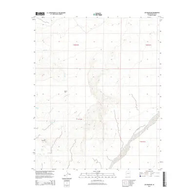
2014 Map of Lee Mountain
USGS Topo · Published 2014About this map
Lee Mountain and the prominent Marcou Mesa dominate this high-desert landscape in Navajo County, recorded during a 2014 survey. The terrain is defined by an intricate network of drainage systems, most notably the winding paths of Joseph City Wash, Billy Wash, and Tanner Wash. These seasonal watercourses dictate the physical geography of the region, creating the complex contour patterns characteristic of the Arizona plateau. Man-made interventions in this arid environment are limited but significant, represented by cattle tanks such as Badland Tank and Baldwin Tank which provide vital water sources in an area otherwise defined by Jacobs Wash and other intermittent streams. The map provides a clear look at the Public Land Survey System grid, showing the intersections of T20N R20E and T19N R21E across this sparsely settled territory.
Find a feature on this map
11 named features on this map. Tap any name to fly to it.
Don’t see what you’re looking for? This feature index may not catch every label — zoom into the map to look around manually.
Map Details
Editions of this 2014 Lee Mountain Map
This is the sole edition of this map. No revisions or reprints were ever made.
Other maps of this area

1883 · Tusayan
USGS Topo · 1:250,000

1886 · Tusayan
USGS Topo · 1:250,000

1886 · Holbrook
USGS Topo · 1:250,000

1893 · Holbrook
USGS Topo · 1:250,000

1947 · Flagstaff
USGS Topo · 1:250,000

1954 · Flagstaff
USGS Topo · 1:250,000

1954 · Holbrook
USGS Topo · 1:250,000

1955 · St. Joseph 1 NE
USGS Topo · 1:24,000

1955 · St. Joseph 1 NW
USGS Topo · 1:24,000
1955 · St. Joseph 2 NE
USGS Topo · 1:24,000