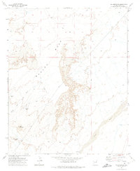
1972 Map of Lee Mountain
USGS Topo · Published 1975About this map
Marcou Mesa dominates this landscape in northern Arizona, rising above the surrounding drainages of the Painted Desert region. This 1972 field-checked survey captures the high-plateau topography and the intermittent water systems that define the area's geography. The map reveals a network of primitive transportation and water management, including the Tanner Trail and numerous Jeep Trails that navigate the slopes of Lee Mountain. Water sources are critical identifiers on this arid terrain, marked by features such as Lee Mountain Tanks, Balbasin Tank, and VK Windmill. The drainage patterns of Joseph City Wash and Leroux Wash illustrate how seasonal runoff has carved the breaks of the mesa, providing essential context for understanding the historic range land and livestock routes of Navajo County during the early 1970s.
Find a feature on this map
11 named features on this map. Tap any name to fly to it.
Don’t see what you’re looking for? This feature index may not catch every label — zoom into the map to look around manually.
Map Details
Editions of this 1972 Lee Mountain Map
This is the sole edition of this map. No revisions or reprints were ever made.
Other maps of this area

1883 · Tusayan
USGS Topo · 1:250,000

1886 · Tusayan
USGS Topo · 1:250,000

1886 · Holbrook
USGS Topo · 1:250,000

1893 · Holbrook
USGS Topo · 1:250,000

1947 · Flagstaff
USGS Topo · 1:250,000

1954 · Flagstaff
USGS Topo · 1:250,000

1954 · Holbrook
USGS Topo · 1:250,000

1955 · St. Joseph 1 NE
USGS Topo · 1:24,000

1955 · St. Joseph 1 NW
USGS Topo · 1:24,000
1955 · St. Joseph 2 NE
USGS Topo · 1:24,000