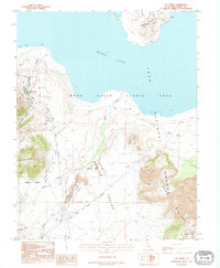
1992 Map of Lee Vining
USGS Topo · Published 1995About this map
Lee Vining serves as the primary gateway to the high-country landscape depicted in this 1990s survey, where the Great Basin meets the Sierra Nevada. The map captures the unique hydrological and volcanic features of the area, including the expansive Mono Lake and the volcanic cluster of the Mono Craters. Centered within the lake is Paoha Island, a landmass formed by volcanic activity that stands as a stark feature in the alkaline waters. The geography transitions from the steep descent of Lee Vining Canyon into the broad expanse of Pumice Valley, illustrating the glacial and eruptive forces that shaped the terrain.
Find a feature on this map
28 named features on this map. Tap any name to fly to it.
Don’t see what you’re looking for? This feature index may not catch every label — zoom into the map to look around manually.
Map Details
Editions of this 1992 Lee Vining Map
This is the sole edition of this map. No revisions or reprints were ever made.
Other maps of this area

1901 · Mt. Lyell
USGS Topo · 1:125,000

1909 · Hawthorne
USGS Topo · 1:250,000

1909 · Bridgeport
USGS Topo · 1:125,000

1911 · Bridgeport
USGS Topo · 1:125,000

1911 · Hawthorne
USGS Topo · 1:250,000

1914 · Mt. Morrison
USGS Topo · 1:125,000

1915 · Hawthorne
USGS Topo · 1:250,000

1920 · Bridgeport
USGS Topo · 1:125,000

1947 · Mariposa
USGS Topo · 1:250,000

1948 · Walker Lake
USGS Topo · 1:250,000