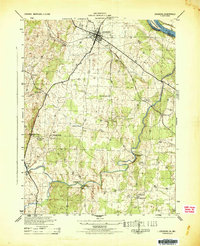
1944 Map of Leesburg
USGS Topo · Published 1944About this map
Leesburg serves as the focal point of this 1944 survey, situated at a vital junction of northern Virginia's road and rail infrastructure. The Washington and Old Dominion railroad cuts across the landscape, connecting the town with the surrounding agrarian countryside. Along the Potomac River to the northeast, the C & O Canal (Abandoned) and Harrison Island mark the state boundary with Maryland, reflecting a transportation era that had already transitioned toward rail and road.
Find a feature on this map
31 named features on this map. Tap any name to fly to it.
Don’t see what you’re looking for? This feature index may not catch every label — zoom into the map to look around manually.
Map Details
Editions of this 1944 Leesburg Map
This is the sole edition of this map. No revisions or reprints were ever made.
Other maps of this area

1884 · Harpers Ferry
USGS Topo · 1:125,000

1890 · Mt. Vernon
USGS Topo · 1:125,000

1891 · Harpers Ferry
USGS Topo · 1:125,000

1891 · Mt. Vernon
USGS Topo · 1:125,000

1893 · Frederick
USGS Topo · 1:125,000

1893 · Harpers Ferry
USGS Topo · 1:125,000

1894 · Warrenton
USGS Topo · 1:125,000

1894 · Frederick
USGS Topo · 1:125,000

1894 · Mt. Vernon
USGS Topo · 1:125,000

1897 · Mt. Vernon
USGS Topo · 1:125,000