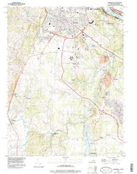
1994 Map of Leesburg
USGS Topo · Published 1998About this map
The town of Leesburg serves as the focal point for this mid-1990s study of Loudoun County, Virginia, where the historic northern boundary meets the Potomac River at Harrison Island. The landscape preserves a notable transition from the recreational corridors of the W&OD Trail and Chesapeake and Ohio Canal National Historical Park to the agricultural and residential pockets of Virts Corner and Gleedsville. Significant regional sites such as Balls Bluff Battlefield Regional Park and the historic Oatlands estate anchor the area's heritage. To the south, the massive Beaverdam Creek Reservoir dominates the drainage of Goose Creek, while industrial activity is noted at a Quarry near Belmont. Transportation infrastructure, including the Leesburg Muni Airport (Godfrey Field) and the crossing at Evergreen Mills, reflects the late 20th-century development surrounding this historic Virginia seat.
Find a feature on this map
38 named features on this map. Tap any name to fly to it.
Don’t see what you’re looking for? This feature index may not catch every label — zoom into the map to look around manually.
Map Details
Editions of this 1994 Leesburg Map
This is the sole edition of this map. No revisions or reprints were ever made.
Other maps of this area

1884 · Harpers Ferry
USGS Topo · 1:125,000

1890 · Mt. Vernon
USGS Topo · 1:125,000

1891 · Harpers Ferry
USGS Topo · 1:125,000

1891 · Mt. Vernon
USGS Topo · 1:125,000

1893 · Frederick
USGS Topo · 1:125,000

1893 · Harpers Ferry
USGS Topo · 1:125,000

1894 · Warrenton
USGS Topo · 1:125,000

1894 · Frederick
USGS Topo · 1:125,000

1894 · Mt. Vernon
USGS Topo · 1:125,000

1897 · Mt. Vernon
USGS Topo · 1:125,000