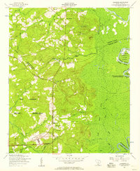
1953 Map of Leesburg
USGS Topo · Published 1957About this map
The Fort Jackson Military Reservation dominates this mid-century landscape in Richland County, where the transition from civilian farmland to military training grounds is clearly visible. The survey captures the small settlement of Leesburg and the rural community of McCaskill, both surrounded by a dense network of country churches and schools such as Concord Church, Mount Pilgrim Church, and Pine Grove School. Along the eastern boundary, the Wateree River defines the edge of the county, bordering the South Carolina Penitentiary State Farm Number One. The terrain is marked by numerous watercourses, including Spears Creek and the expansive White Swamp, illustrating the well-watered but often challenging geography of the region. Military infrastructure like a rifle range and a tank are mapped alongside older landmarks like Dunns Mount, providing a detailed look at how the expansion of Fort Jackson transformed local geography.
Find a feature on this map
55 named features on this map. Tap any name to fly to it.
Don’t see what you’re looking for? This feature index may not catch every label — zoom into the map to look around manually.
Map Details
Editions of this 1953 Leesburg Map
This is the sole edition of this map. No revisions or reprints were ever made.
Other maps of this area

1935 · Killian
USGS Topo · 1:48,000

1937 · Killian
USGS Topo · 1:62,500

1938 · Hagood
USGS Topo · 1:62,500

1941 · Spartanburg
USGS Topo · 1:250,000

1942 · Camden
USGS Topo · 1:125,000

1943 · Eastover
USGS Topo · 1:62,500

1948 · Hopkins
USGS Topo · 1:62,500

1953 · Camden South
USGS Topo · 1:24,000

1953 · Messers Pond
USGS Topo · 1:24,000

1953 · Eastover
USGS Topo · 1:24,000