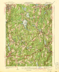
1941 Map of Leicester
USGS Topo · Published 1941About this map
The hills of Worcester County are defined by a network of textile-era settlements and glacial ponds just before the mid-century. Leicester and Spencer anchor the northern landscape, while the industrial corridor of the French River connects Rochdale and North Oxford. This survey, compiled in part from aerial photography, captures the transition from old manufacturing centers to a more recreational and residential landscape, visible in the presence of the Mt Pleasant Golf Club and Hillcrest Country Club. Local history is deeply embedded in the land, from the Clara Barton Home near Oxford Heights to the numerous burial grounds like Bay Path Cem. The hydrography of the region is prominent, featuring the expansive Stiles Reservoir and smaller bodies like Burncoat Pond and Cedar Meadow Pond that once powered local industry. The Boston and Albany RR cuts through the western terrain, serving established towns like Charlton Depot and Charlton City.
Find a feature on this map
80 named features on this map. Tap any name to fly to it.
Don’t see what you’re looking for? This feature index may not catch every label — zoom into the map to look around manually.
Map Details
Editions of this 1941 Leicester Map
2 editions found
Other maps of this area

1885 · Worcester
USGS Topo · 1:62,500

1886 · Worcester
USGS Topo · 1:62,500

1887 · Brookfield
USGS Topo · 1:62,500

1887 · Barre
USGS Topo · 1:62,500

1889 · Webster
USGS Topo · 1:62,500

1889 · Barre
USGS Topo · 1:62,500

1890 · Brookfield
USGS Topo · 1:62,500

1892 · Webster
USGS Topo · 1:62,500

1892 · Worcester
USGS Topo · 1:62,500

1893 · Brookfield
USGS Topo · 1:62,500