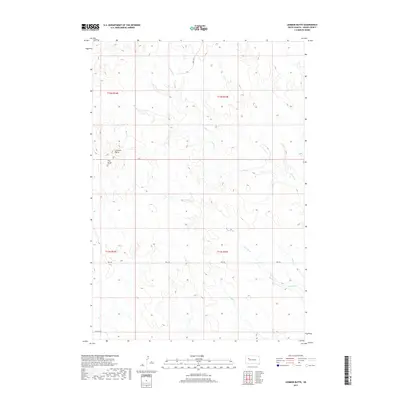
2017 Map of Lemmon Butte
USGS Topo · Published 2017About this map
Lemmon Butte and Hay Butte stand as the primary topographic landmarks in this portion of Meade County, rising above a landscape defined by an intricate network of drainage channels. The area's hydrology is characterized by the branching paths of N Brushy Cr and Brushy Cr, which weave through the northern sections, while Johnny Cr and Middle Cr dominate the south. These intermittent streams create a deeply textured terrain typical of the western South Dakota plains. Transportation is concentrated along a few key corridors, notably Opal Rd, which serves as a vital horizontal link across the prairie. Other local routes like Udager Pl and Twilight Pl provide access to the remote sections of the quadrangle. This 2017 survey reflects the enduring character of this rural landscape, where land use is dictated by the natural flow of the creek systems and the prominent buttes that break the horizon.
Find a feature on this map
14 named features on this map. Tap any name to fly to it.
Don’t see what you’re looking for? This feature index may not catch every label — zoom into the map to look around manually.
Map Details
Editions of this 2017 Lemmon Butte Map
This is the sole edition of this map. No revisions or reprints were ever made.
Other maps of this area

1952 · Deep Creek SE
USGS Topo · 1:24,000

1952 · Signal Butte
USGS Topo · 1:24,000

1953 · Rapid City
USGS Topo · 1:250,000

1954 · Lemmon
USGS Topo · 1:250,000

1957 · Lemmon
USGS Topo · 1:250,000

1957 · Rapid City
USGS Topo · 1:250,000

1983 · Lemmon Butte
USGS Topo · 1:24,000
1983 · Avance
USGS Topo · 1:24,000
1983 · Opal East
USGS Topo · 1:24,000

1983 · Opal East SW
USGS Topo · 1:24,000