
1983 Map of Opal East
USGS Topo · Published 1984About this map
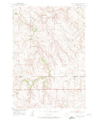
Fox Ridge defines the northern reaches of this Meade County landscape, where the drainage networks of the Beaver Dam Creek branches carve through the high plains. The small settlement of Opal serves as a local anchor in the southern portion of the sheet, situated near the West Branch Beaver Dam Creek. This 1980s-era survey captures the area’s ranching character, marked by scattered landmarks like Mud Butte and the extensive Opal Lake State Game Production Area. Genealogists and local historians will find specific interest in the Backes Cem and another smaller Cem located nearby, which provide tangible links to the early families who settled this part of the South Dakota prairie. The map details a transition in topography where the prominent ridge lines give way to the complex, meandering creek beds that define the local watershed.
Find a feature on this map
12 named features on this map. Tap any name to fly to it.
Don’t see what you’re looking for? This feature index may not catch every label — zoom into the map to look around manually.
Map Details
Editions of this 1983 Opal East Map
This is the sole edition of this map. No revisions or reprints were ever made.
Other maps of this area

1951 · Maurine
USGS Topo · 1:24,000
1952 · Deep Creek SE
USGS Topo · 1:24,000
1952 · Signal Butte
USGS Topo · 1:24,000

1953 · Rapid City
USGS Topo · 1:250,000

1954 · Lemmon
USGS Topo · 1:250,000

1957 · Lemmon
USGS Topo · 1:250,000

1957 · Rapid City
USGS Topo · 1:250,000

1983 · Opal West SE
USGS Topo · 1:24,000

1983 · Lemmon Butte
USGS Topo · 1:24,000

1983 · Opal East SW
USGS Topo · 1:24,000