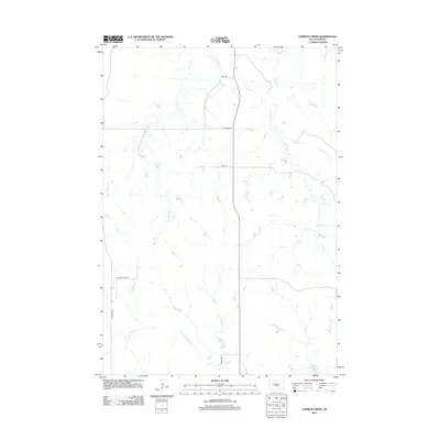
2012 Map of Lemmon Creek
USGS Topo · Published 2012About this map
Lemmon Cr and Cherry Cr define the hydrological character of this Ziebach County landscape, where an intricate network of intermittent drainages carved into the high plains. The map reveals a rural infrastructure of section-line roads and remote crossings, such as Zeal Rd and Co Hwy MC-24, which navigate the subtle rises and falls of the terrain. The presence of Howes Grazing Lake in the southeast corner indicates the vital role of water management in this livestock-grazing region. Smaller tributaries like Negro Cr, Luis Cr, and E Br Narcelle Cr further detail the complex watershed, illustrating how local ranching operations likely rely on these seasonal watercourses and the modest tracks that connect them across the prairie.
Find a feature on this map
16 named features on this map. Tap any name to fly to it.
Don’t see what you’re looking for? This feature index may not catch every label — zoom into the map to look around manually.
Map Details
Editions of this 2012 Lemmon Creek Map
This is the sole edition of this map. No revisions or reprints were ever made.
Other maps of this area

1953 · Rapid City
USGS Topo · 1:250,000

1954 · Pierre
USGS Topo · 1:250,000

1955 · Bridger
USGS Topo · 1:24,000

1955 · Howes
USGS Topo · 1:24,000

1957 · Rapid City
USGS Topo · 1:250,000

1958 · Pierre
USGS Topo · 1:250,000

1982 · Chasing Hawk Draw
USGS Topo · 1:24,000

1982 · Dead Horse Draw
USGS Topo · 1:24,000

1983 · Plainview
USGS Topo · 1:24,000
1983 · Avance SE
USGS Topo · 1:24,000