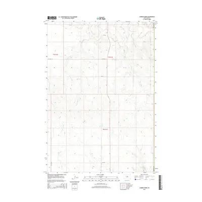
2015 Map of Lemmon Creek
USGS Topo · Published 2015About this map
Cherry Cr and its various tributaries, including Brushy Cr and Rose Cr, weave through this section of Ziebach County, defining a landscape shaped by intermittent watercourses. The drainage network is dense here, with Lemmon Creek and Johnny Cr cutting through the terrain alongside family-named landmarks like Green Berry Cr and E Br Narcelle Cr. This 2015 U.S. Geological Survey representation shows a rural landscape primarily organized by section lines and gravel routes such as Old Marcus Rd and Zeal Rd. In the southeastern corner, Howes Grazing Lake and the nearby Luis Cr provide significant points of interest for those studying the local hydrography and ranching history near the Meade County border.
Find a feature on this map
20 named features on this map. Tap any name to fly to it.
Don’t see what you’re looking for? This feature index may not catch every label — zoom into the map to look around manually.
Map Details
Editions of this 2015 Lemmon Creek Map
This is the sole edition of this map. No revisions or reprints were ever made.
Other maps of this area

1953 · Rapid City
USGS Topo · 1:250,000

1954 · Pierre
USGS Topo · 1:250,000

1955 · Bridger
USGS Topo · 1:24,000

1955 · Howes
USGS Topo · 1:24,000

1957 · Rapid City
USGS Topo · 1:250,000

1958 · Pierre
USGS Topo · 1:250,000

1982 · Chasing Hawk Draw
USGS Topo · 1:24,000

1982 · Dead Horse Draw
USGS Topo · 1:24,000

1983 · Plainview
USGS Topo · 1:24,000
1983 · Avance SE
USGS Topo · 1:24,000