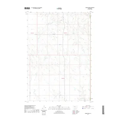
2017 Map of Lemmon Creek
USGS Topo · Published 2017About this map
Lemmon Creek winds through this cattle country in northwestern South Dakota, where the landscape is defined by the complex drainage systems of the Cheyenne River watershed. The terrain is marked by a network of seasonal streams, including Cherry Cr, Negro Cr, and Johnny Cr, which carve into the plains of Ziebach County. Near the southern boundary, Howes Grazing Lake serves as a vital water source in this semi-arid environment, illustrating the ranching-driven land use patterns of the region. Transportation follows a sparse but functional grid, with routes like Zeal Rd and Old Marcus Rd connecting isolated rural holdings across t9n r17e and surrounding townships. This 2017 survey reflects the enduring character of the High Plains, where human presence is sparse and closely tied to the natural hydrology of places like E Br Narcelle Cr and Brushy Cr.
Find a feature on this map
19 named features on this map. Tap any name to fly to it.
Don’t see what you’re looking for? This feature index may not catch every label — zoom into the map to look around manually.
Map Details
Editions of this 2017 Lemmon Creek Map
This is the sole edition of this map. No revisions or reprints were ever made.
Other maps of this area

1953 · Rapid City
USGS Topo · 1:250,000

1954 · Pierre
USGS Topo · 1:250,000

1955 · Bridger
USGS Topo · 1:24,000

1955 · Howes
USGS Topo · 1:24,000

1957 · Rapid City
USGS Topo · 1:250,000

1958 · Pierre
USGS Topo · 1:250,000

1982 · Chasing Hawk Draw
USGS Topo · 1:24,000

1982 · Dead Horse Draw
USGS Topo · 1:24,000

1983 · Plainview
USGS Topo · 1:24,000
1983 · Avance SE
USGS Topo · 1:24,000