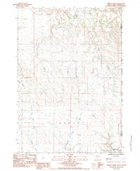
1983 Map of Lemmon Creek
USGS Topo · Published 1984About this map
Cherry Creek meanders through the northern reaches of this landscape in the early 1980s, carving a complex drainage network into the South Dakota plains. The eastern edge of the quadrangle is defined by the Cheyenne River Indian Reservation Boundary, marking a significant jurisdictional division that separates Meade Co from Ziebach Co. The terrain is characterized by a dense system of seasonal watercourses and draws, including Lemmon Creek, Johnny Creek, and Brushy Creek, which converge as they move toward the larger creek valley.
Find a feature on this map
14 named features on this map. Tap any name to fly to it.
Don’t see what you’re looking for? This feature index may not catch every label — zoom into the map to look around manually.
Map Details
Editions of this 1983 Lemmon Creek Map
This is the sole edition of this map. No revisions or reprints were ever made.
Other maps of this area

1953 · Rapid City
USGS Topo · 1:250,000

1954 · Pierre
USGS Topo · 1:250,000

1955 · Bridger
USGS Topo · 1:24,000

1955 · Howes
USGS Topo · 1:24,000

1957 · Rapid City
USGS Topo · 1:250,000

1958 · Pierre
USGS Topo · 1:250,000

1982 · Chasing Hawk Draw
USGS Topo · 1:24,000

1982 · Dead Horse Draw
USGS Topo · 1:24,000

1983 · Plainview
USGS Topo · 1:24,000
1983 · Avance SE
USGS Topo · 1:24,000