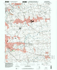
1999 Map of Leola
USGS Topo · Published 2001About this map
The Conestoga River and Pequea Creek define the landscape of this Lancaster County quadrangle, a region where agricultural traditions meet late-twentieth-century development. In the years before the new millennium, the corridor along Lincoln Highway and Old Philadelphia Pike shows significant growth, with a dense network of country schools like Sunnyside Sch and Good Sch serving the surrounding farmsteads. The map captures the distinct character of settlements like Bird in Hand, Smoketown, and Leola as they balance their historic village identities with modern infrastructure.
Find a feature on this map
75 named features on this map. Tap any name to fly to it.
Don’t see what you’re looking for? This feature index may not catch every label — zoom into the map to look around manually.
Map Details
Editions of this 1999 Leola Map
This is the sole edition of this map. No revisions or reprints were ever made.
Other maps of this area

1902 · Lancaster
USGS Topo · 1:62,500

1904 · Lancaster
USGS Topo · 1:62,500

1906 · New Holland
USGS Topo · 1:62,500

1908 · New Holland
USGS Topo · 1:62,500

1912 · Quarryville
USGS Topo · 1:62,500

1912 · Mc Calls Ferry
USGS Topo · 1:62,500

1941 · New Holland
USGS Topo · 1:62,500

1943 · Lancaster
USGS Topo · 1:62,500

1943 · Quarryville
USGS Topo · 1:62,500

1943 · Mc Calls Ferry
USGS Topo · 1:62,500
Featured Places
- West Lampeter Township, PA
- Leacock, Upper Leacock Township
- Paradise Township, PA
- Brownstown, West Earl Township
- Manheim Township, PA