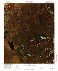
1980 Map of Lewis Swamp
USGS Topo · Published 1985About this map
Lewis Swamp and the surrounding wetlands of Brunswick County define this 1980 orthophotoquad, which utilizes color infrared aerial photography to reveal the dense hydrology of southeastern North Carolina. Small rural clusters and crossroads like Rabontown and Flowers Corner are scattered through a landscape dominated by timber and drainage networks. The distinct signatures of vegetation and moisture are visible in the large expanse of Green Swamp to the west and the circular depression of Redwater Bay to the southeast.
Find a feature on this map
12 named features on this map. Tap any name to fly to it.
Don’t see what you’re looking for? This feature index may not catch every label — zoom into the map to look around manually.
Map Details
Editions of this 1980 Lewis Swamp Map
This is the sole edition of this map. No revisions or reprints were ever made.
Other maps of this area

1943 · Funston
USGS Topo · 1:24,000

1943 · Honey Island
USGS Topo · 1:24,000

1943 · Winnabow
USGS Topo · 1:24,000

1943 · Bolivia
USGS Topo · 1:24,000

1943 · Supply
USGS Topo · 1:24,000

1943 · Lewis Swamp
USGS Topo · 1:24,000

1944 · Supply
USGS Topo · 1:31,680

1944 · Bolivia
USGS Topo · 1:31,680

1944 · Winnabow
USGS Topo · 1:31,680

1944 · Lewis Swamp
USGS Topo · 1:31,680